Photo-Journal

Branching Out

There have been a few moments on here where I have seemed MIA. This is not for lack of effort. Recently I have had some exciting opportunities to work together with some incredible people promoting some great causes with videos. Both of the projects, The Watershed Research Cooperative and Driftwood Magazine were successful in bringing their messages to the public.  For instance, the Watershed Research Cooperative video was used to highlight one of the most extensive research projects in existence, discussing the impacts of timber harvest on headwater streams and the life within them. Frank Creative, the people behind the scenes on this project were some of the best people to work with.

Driftwood magazine came to me asking for help with their Kickstarter video, which is key to running a successful campaign. With the video and rewards offered Driftwood magazine was able to receive enough support and as you read this the first printed edition is in the works. You can see the video and read more about their campaign at Driftwood Magazine.

Working with both of these groups was such an amazing experience for me and allowed me to bringing my creativity to causes I believe in. Lets see if we can keep projects like these coming to the blog more often.

Mark

Collective: Nic & Preston

Collective: Nic & Preston

One of my motivations for first picking up a camera was to share with the rest of the world all the interesting people who have been an inspiration to me in one form or another. My latests project involved two perfect examples of this. Collaborating with Pusher Bmx Shop, rider owned and ran with the concept of giving back to the local scenes, I was given the chance to film two good friends, Nic Bonner and Preston Levi Solis. Originally the plan was to film with Preston, but after finding out Nic had recently moved back to town and getting some daily sessions in with Preston like days long past I couldn't pass up the chance to involve him in the project. One thing I learn repeatedly is to let the story develop itself organically. The addition of Nic meant some hilarious antics and some badass colorado sessions. From the variety of clips and b reel we filmed together over a long weekend in May putting together a compelling story seemed to work out better than could be expected. Projects like this are ones that motivate me to grow and learn more, to further tell a more inspiring story.

Year of the Hammock: Part One

UpperFalls_SideCreek2_web I'm laying claim to it right now, declaring this the year of the hammock. This is a simple concept, but maybe not such a simple task to conquer. Any of my time spent overnight in the elements will be spent stretched out in a hammock, at least whenever possible. The benefits are pretty clear to me already; comfort, light weight, quick to set up, second use as a hanging seat. But, there are lots of possible problems and obstacles in the way including weather, and terrain. Here is a good video of one setback on the first overnight of the year.

[video_lightbox_youtube video_id="hLDOz7VVRKk&rel=0" width="640" height="480" auto_thumb="1"] But I won't be deterred so easily. Like any other time we fail at something, we pick ourselves up an try again. Perseverance is necessary when you take on a task with as many obstacles as this. The Lewis river hike brought out this fact. An incredibly scenic hike on the southeast side of Mount St helens, the Lewis river offers several iconic northwest waterfalls, as well as some enormous old growth forests. Anthony Buglio, Ben Lyons and myself made the 2.5 hour trip out to the Lower Lewis River Falls, where the trail begins. Many people may question why anyone would go backpacking during some of the coldest and definitely most wet months of the year. That is exactly why we went backpacking. The three of us decided we needed a night out braving the elements and attempting to blindly ignore the cold, wet climate. It was a Worst Day of the Year kind of hike.

UpperFalls_Portrait2_web

Its was a chilly and damp start as we headed up river away from the lower falls and campground. The trail was clear of snow and ice for the first portion, but what it lacked in winter elements it made up by ways of washouts and fallen widow makers (large, heavy limbs). Before we reached the middle falls we were detoured out towards a fire road and around back to the trail. We didn't catch site of it, but the signs along the trail mentioned a large mudslide that wiped out the trail. The hike around added about a mile, but brought us past some side falls and dense forests of massive Doug Firs. We found our way back to our original path just in time to catch a glimpse of middle falls.

Soon after enjoying a break at the bottom of middle falls we started back up the switchbacks heading further up the river. This was the area we began to see sites of winter. Areas of the trail had patches of snow or piles of fist size chunks of ice. The overcast never cleared up that day but our spirits remained high as we continued up the trail in search of a good spot for camp. Soon we came to a couple areas where the trees thinned out and the ground leveled close to the river. Old growth stands that survived the last timber boom up in this area stand as monuments of the strength of nature if left to flourish on its own.

BigTrees_LittlePeople1-web

A couple inspections later and we found our home base for the night. No time for the weary though as we dropped off our bags and finished the hike up to the Upper Lewis River falls, which remained visible from our camp site, through the bare limbs of the brush on the river bed.

Buglio_CampViewFalls_web

The volume of water cascading over the rocky edge of the falls everyday is staggering. This makes for some amazing scenery, but as we learned later that night it also creates a big obstacle for our campsite not far down stream. With the temperatures getting down into the high 20s, low 30s we knew a fire would be an essential element to make tis trip a comfortable one. Ben brought some fire starters with this very idea in mind. It was hard to determine why exactly our failed attempts at creating fire were happening until the following day when breaking down the camp. The weather was clear the night before, yet anything out in the elements collected a layer of moisture we didn't have the day before. Apparently the power of the waterfall created a thin mist of water that constantly blanketed everything down river.

UpperFalls_Lexp2_web

We persevered though, waking up the next day to pockets of sunlight breaking through the clouds. We made one last exploration up to the top of the falls and down to the base of it before packing up and heading home. The area around the Upper falls is a just reward for the short 4 miles each way, giving way to several sites of the Lewis River, waterfalls of varying sizes, and trees large enough to transport you to the land of the lost. During the more comfortable summer months this trail is known to be busy with day hikers and backpackers alike, but our trip only a few weeks into the new year meant we had more room for enjoyment outside the normal encroachment of human society. It was well worth the cold, damp night. And to be honest, I feel I had a comfortable sleep during the night, laying dry, suspended above the wet, cold ground. Chalk up the first trip of the year, the year of the hammock. I imagine its only going to get better.


National Justice For Animals Week

http://youtu.be/jZmdLn_C1g8?list=UUNlYdrIaEC2c2H9r5Lbc3qg Recently I had the opportunity to help out an incredible cause by filming and editing a piece on Gracie, a beautiful Alpaca who draws your attention the very moment you lay eyes on her. As the organization behind the rescue of Gracie and the prosecution against her abuser, ALDF (Animal Legal Defense Fund) raised funds and provided various resources to help with the case. All in all Gracie was rescued with over 150 other Alpacas, but with Gracie's gentle demeanor and fascinating markings she was chosen to stand as an ambassador for all animals neglected and abused during National Justice For Animals week, and show how a battered beautiful being such as her can be given a second chance at a life of comfort and happiness. The project was filmed over the course of a month, in locations such as Cross Creek Alpaca Rescue and Portland ALDF offices. The video helps to bring awareness to the ALDF organization, the work they do for animals, and the need for people to stand up for these animals that lack a voice to express their pain and horror. Take a moment to visit these organizations online and understand more about who they are and how you can help.

Blythe & Bennett Presents: THE SLUTTY HEARTS

SluttyHeartsCrowd1-web

It is an incredible experience to witness an idea come to fruition; a vision contemplated by two friends. For many of us in Portland we got to see this happen with our friends Patrick Dennehy and Matt Roveto in their creation of Blythe and Bennett Records, a small but influential record shop in the heart of the Belmont neighborhood. The transition from an empty store front to a completely functioning shop with bins stacked deep with records and posters blanketing the wall solidified their vision into a reality.

Almost a year later and Blythe and Bennett has found themselves at another milestone. The shops first big in store show with local band The Slutty Hearts recently happened, with a good size crowd coming out for the show.

http://www.sluttyhearts.com/

Yobeat's Mogul Mayhem

Yobeat's Mogul Mayhem at Timberline from YoBeat

This past year I was able to be on location of some of the most creative snowboard contests I have seen in a long time. Starting the season off right with a banked slalom contest at Mount Bachelor and ending with the latest Yobeat creation, Mogul Mayhem, in collaboration with Timberline Lodge. I haven't even seen a mogul run since my teenage years in the icy states of New England. The jam format, playlist of some 80's and 90's hits, and some of  the Timberline park builder's skills created a good atmosphere and course for some mogul slashing. I am always psyched when I get a chance to capture one of these contests so when I had the chance to edit this video of the day to go along with the photography of Jared Souney and camera work of Danny Kern I didn't pass it up. Really excited to see more contests like these in the future.

Eagle Creek

SilhouetteHiker-web

One of the reasons I was drawn to the northwest is the infinite amount of natural landscape; each one different than the next. Even in a lifetime a person would be hard pressed to see it all. 

Eagle Creek lies 42 miles from Downtown Portland. It has been one of the staple locations to bring anyone coming to visit the area. Within the first 2 miles the hike offers some great vantage points over the river leading into the Columbia River Gorge and at least 3 waterfalls that deserve some time to appreciate.


punchbowl1Punchbowl is the most infamous waterfall on this hike. Cascading around 2 miles in it becomes a great destination for a short hike. For some years this has been as far as I have explored. When Ben talked about hiking eagle creek I saw the opportunity to venture further up river to Tunnel Falls.

TunnelFalls1

After passing several other waterfalls, a few bridge crossings and what looks to be some promising camping spots for the near future we came to Tunnel Falls. At 165 ft. the water cascades from the forest above, streaming over an 8' by 6' tunnel which travels behind the falls. The trail continues on from here up to Wahtum lake. At almost 13 miles this would be an adventure for another day. 

FallsUpRiver2-web

Eagle Creek trail to Tunnel Falls made for a good days hike, with several points of interest along the way.

SmokeyMountains1

The weather was cold at times, but remained dry and sunny for much of the day. After being further up river I know there will be more days spent up here exploring.

LightThroughDark1


What I'm Thankful For

Silverstar-Hood1

Thanksgiving comes around towards the end of every year. It is the time of year the seasons are in flux; people start to hunker down until the spring when everything comes alive again. After an intense amount of time spent working or in front of my computer I decided to spend the holiday exploring new terrain out in the forest instead. Considering the holiday and the end of the season I knew the trails would be light with traffic and escaping society would be easy, which is exactly what I wanted. It is always good practice to hike with a friend, so I was happy to hear Ben was looking for some similar solitude and decided to join me.

The hike was originally intended to be a little more than 6 miles up and back, but because we attempted a different route back we added a couple of miles and some time bushwhacking to cut across a valley back up to the correct trail from a different ridge. Silver Star gets its name from the pattern of ridges that descend from the summit, creating a star pattern. There is a loop trail that circles around the summit so one wrong choice in trails could lead a person to venture down the wrong ridge.

Silverstar-Portrait

Silver Star summit has been on my radar for a few years now. Standing tall at 4,364' it is known for having some of the most jaw dropping views of the more well-known giants around it. Towards the north views of Mount St. Helens and Mount Rainier fill the void in the sky.

SilverStar-Adams1

Towards the east, northeast direction Mount Adams stood alone.

Looking south you were greeted with some of the best views of Mount Hood in my opinion. Representing Oregon's wealth in natural landmarks Hood jets upwards and on a good day (not hazy or cloudy) Mount Jefferson can be seen standing to the south.

Silverstar-HikerSilhouette2

Silverstar-Southwest1

Sturgeon Rock sits below the summit on the western slope. On the hike up Grouse Trail we kept thinking this was our destination, but with the summit remaining hidden behind a few ridges we were wrong. Sturgeon rock adds some good foreground contrast to the many mountains that fade into the horizon.

Silverstar-HikerSilhouette1

Up on the summit we spent some time enjoying the Tofurkey, peas and corn I made the night before. On the lower summit we noticed another hiker who had similar ideas for the holiday. Sitting up there, taking in the 360 degree views of some of the northwest's largest natural monuments, I was giving thanks for the opportunities and inspirations that lead to my adventure and the many other experiences that came before this. Knowing I am not alone in sharing this feeling gives me confidence for the future generations.

The (Vegan) Caterer presents: Harvest Supper

On friday, November 15 The (Vegan) Caterer, along with several other volunteers and sponsors came together to show support for Pigs Peace Sanctuary, located in Northwestern Washington. With a silent auction, great plant based food, educating and inspiring speeches, and an all around night of important discussions on animal welfare, the benefit was able to raise $4,082.90 for the sanctuary. This video shares a small piece of these speeches and dinner, along with footage from the sanctuary. For more information on this event and the sanctuary itself, including how you can volunteer or donate to Pigs Peace Sanctuary, follow the links below.

Kawehi

Criminal from Kawehi on Vimeo.

This blog was originally created for me to showcase some projects I have done or have contributed to. In anticipation for a much larger project I am hinting to now I want to include stories about other people who are inspiring and talented in a way I think should be noted. Kawehi is a good representation of this.

USA, The Cover Series: IMAGINE by John Lennon (Cover by Kawehi) FOR PETER from Kawehi on Vimeo.

For now lets consider the D.I.Y aspect of her work. She gives her perspective on a song using loop pedals and different acoustics to create unique covers. Not only this, but she uses the power of vimeo to showcase it for everyone to see. There is no huge profit margin for this woman; just the absolute love for what she does. Set up shop in front of the camera, press record, begin to shape the audio, then share it with the world. Her use of Kickstarter to fund her projects is an incredible way for her to keep rights and control for her to decide. It also eliminates the middle man, allowing the audience to interact and to be a part of her work. All of these points show that the "do it yourself" attitude is one to be admired and learned from.

USA, The Cover Series: ROYALS (cover by Kawehi) from Kawehi on Vimeo.

Beyond the fact she chose to create the music she has and document it on her own lets consider the work she actually has accomplished. I really appreciate the direction you can go when covering another song. You can play the cover almost completely unchanged, paying homage to the original artists; but when a person takes that cover song and puts in their little twists and shapes to bring a version of how that song sounds to them they can really come out with styles that may have not been considered before. There are those that should remain as not to be considered, but there absolutely are many that bring a song to life in a whole new way. Kawehi is the latter. Her renditions expand into new avenues by using stacked loops of harmony and beats interlaced with some great vocals. I suggest everyone following her and showing her support.

Thunder in the Enchantments

EnchantmentPeak1-web

The Enchantment Lakes Basin is considered one of the best hikes in in the Northwest United States. Settling just outside the Bavarian themed town of Leavenworth, Washington you begin to realize the incredible diversity of the terrain with each mile driven on the way to the trail heads. The popularity of this area and the need for care and conservation has led to a lottery system for anyone who wishes to backpack in. Planning over 6 months in advance means you have time to prepare and plan for the journey. This also means you have very little control on what the conditions entail. 

A couple years ago I was lucky enough to be granted a permit for Colchuck lake, which is one of the key spots to create a base camp for exploring the area, including what can be seen as the holy grail, The Upper Enchantment Lakes in the core. Our dates were timed well with extremely favorable conditions and picks for camping spots. This trip can be seen at Journey Into the Enchantments.

Moving onto present day I was able to get another permit for similar dates and following the same plan and trail path as we did before. Unfortunately 3 of my past companions weren't able to come along, which led to 4 new people signed up for the journey. In a much different pattern of events this time through we were only 2 hikers in number by time September 4 came along. Also, after researching the conditions a bit we realized we were going in under unfavorable conditions. Unlike before we found ourselves looking at 100% chance of rain and possibilities of scattered thundershowers. Usually in a case such as this it would be good to reconsider the plans and alter them for better conditions, but being as things are with such advance planning we decided to chance it anyways. Signs of a challenging adventure began to arise only half way to the Enchantments from Portland. Driving along the highway just north of Yakima the car began to shutter as the smell of torn rubber trailed close behind. The side walls of the front tire blew out and we came to a halt on the side of the road. A quick ten minuted change and an old spare secured to the car and we were on our way again. We pulled into the parking lot of the Stuart Lake Trailhead around eleven at night. This is where we would begin our journey early the following morning. Sleep was essential , but not until I got a few shots of the night sky.

TrailheadStars1-web

At the time we didn't realize this would be the last time we saw completely clear skies for the rest of our trek. Within a few hours the first wave of heavy rain, and thunder and lightening began. "Good thing we weren't camping yet", is what we were considering. Early the next morning we climbed out of the car with the increasing light to prepare for the hike in to Colchuck Lake.

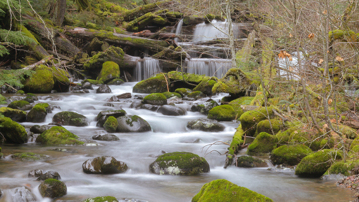
The heavy rain from the night before didn't cause too many issues on the trail in. A few puddles and looming clouds were all that remained. Soon after we started in I began to notice a stark difference from the last trip up here; the trail was empty of any other hikers. About 3 1/2 hours into the first part of our hike we arrived at Colchuck Lake. This alpine lake that sits just above 6,000 ft. in elevation would become base camp once again.

ColchuckLake1-web

We found almost every camp site open, besides the ones occupied by backpackers from the night before.

ColchuckCamp1-web


Not long after we built camp I started to notice the numbers of other campers dwindling as they began to hike out. Soon we were all that remained; besides the hawks fishing in the lakes from above and the chipmunks who are less intimidated by people and more interested in what you may have for a snack.

ColchuckNeighbor1web

As we explored the area around the lake and relaxed with the site of Enchantment Peak (8250') and Dragon Tail Peak (8,842') looming in the background we started to consider what was in store for us the following day.

ColchuckJosh1-web

Aasgard Pass sat in between these two giants, almost taunting us with breaks in the fog shining sunlight down on it. Josh, who made up the other half of our group sat with wonder at what we were about to attempt. We figured the bad weather for the day came early that morning and we would hopefully be waking up the next day to great weather. After a warm meal of trail tacos we climbed in the tents and laid down to sleep. Not long after the flashes of light began, followed by distant rolls of thunder. Within minutes the tent began to light up with flashes  over and over again. Five seconds between some flashes, ten seconds between others, the site of the peaks being assaulted just outside the tent began to bring some concerns on. I considered maybe this is why we don't have any neighbors around the lake or on the trail with us. As the heavy rain began to batter the tents, the flashes becoming brighter and the thunder growing louder I realized there was not much else to do but lay down and hope for the best until it was over. After four hours of a constant attack and a few moments of sleep the storm finally passed. I took the time to assess the damage with the break in the rain to find channels of water passed by the edges of my tent leaving me unscathed. Josh wasn't so lucky and awoke the next day to a wet floor inside the tent. We considered ourselves lucky to witness such a dramatic scene and decided to prepare for our hike into the core.

The weather seemed to lighten up and besides the shroud of thick fog that rolled like a wave over the peaks we figured we may have a good opportunity to explore everything the core had to offer. The first, and most grueling step of the trip was the hike across a slippery boulder field and up Aasgard pass. The trail up the pass is a strenuous 2 mile hike with an elevation gain of about 2500'. The trail on a nice day can only be navigated by the cairns (rocks piled up for markers). By time we even found ourselves at the bottom of the pass we had already lost the trail a few times due to washouts and fast-moving streams that replaced the once worn in trail. The pass on this day was engulfed in thick fog and drizzling rain. We started up hoping for better weather to be waiting just over the top in the core.

AasgardJosh2-web

As we continued on we noticed the rain was beginning to take a harder form and hail was the result. After a steep hike, sometimes requiring hand over hand climbing, we found ourselves cresting the top of the pass. We had a short opportunity to look down on the lake, just before the clouds once again filled the area. We continued deeper into the core considering the different areas we wanted to see. The dark clouds to the east created some skepticism, but after all that work we were not going to be turned around so easily. We pushed in a few miles, exploring the many glacial waterfalls and runoff that filled the aqua blue lakes.

EnchantmentsGlacierFalls1-web

The peaks jetted out of the clouds, looking down on us.

DragonTail1-web

Within an hour we had noticed the weather rolling in and decided to set a limit. We would reach a point where the land cascades steeply into a lake on the far side of the core. At that point we would assess the situation again and start our hike back to the pass. Once again the weather had something else in mind. The minute we arrived at the point we were inundated with hail and freezing rain. It didn't take long before we decided to make a speedy walk back towards the pass. Within ten minutes the thunder and signs of lightning began to appear again. In the core you don't have too many, if any options for cover. Just large boulders and tall peaks remain as the last defense. In a short amount of time we found ourselves back at the top of Aasgard pass, where we stopped briefly to commemorate the days adventure and consider our accomplishments. Not long after we began to start the descent, battering our knees with every step we took. Not too far from the top we came across a group of four women with shorts, thin shirts and small packs making their way up. As this was the first sign of people we have seen in a day we stopped to warn them of what we came across up in the core. Even as the rain continued to fall the women decided to ignore our warning and push through to complete their long and strenuous day hike through the enchantments on a 16 mile loop. I hoped the weather improved for them, since even with our thick layers and rain gear we found ourselves becoming cold.

At the bottom of the pass we began to see other hikers pushing around the lake and passing it on the way up to the core. After a few conversations we found out about the severe weather warning issued by the forestry service the night before. Almost all of the people we came across had decided to forego the first night and wait for the better weather to roll in on the following day. Due to our wet gear and exhaustion from the bad weather we decided to rest up for an hour, pack up, and make our way down, opting out of the last night around Colchuck.  Halfway down towards the trailhead the sun began to break through and shine down on the saturated trail. We laughed at the irony of the weather timing itself so well with our every move and discussed how lucky we were to be able to enjoy this mystical area, even with the harsh conditions we had. In one day we ascended 2500' and descended 5,000', along 12 miles of trails. That was one of the longest days I have had with a full pack on.

On the drive home Josh and I talked about our adventure and what could be in store for the next trip up in 2014, with luck of obtaining another permit. Some may regret the hiking and camping in harsh conditions, but this was an adventure to be experienced, and now we both have a great story to pass on to others. The only thing different I would recommend is to take the weather warnings more seriously the next time.

Montana Country

MontanaCabin-Foothills1-web

Well the summer of 2013 is coming to an end, and this year it brings a heavy amount of exploration and adventure. One such journey led me to Montana to spend time with my family. There was a good point in my life where my apartment windows held the eastern face of the rocky mountains in them. This time started a fire in me; one that calls me to the mountains and everything in between. I got a reminder of this once again when I left the Denver airport headed north towards Bozeman, Montana. 

MontanaMountains1-web

Montana exceeded my expectations, which is a pretty big obstacle since I went into this trip with high hopes. Base camp was nestled in a rustic cabin at the bottom of Emigrant Mountain. A few miles from any signs of pavement, the only neighbors we encountered were the vast amount of deer and cattle. Warnings of bear country and the sounds of coyotes kept things interesting during the stay, but besides one encounter with a lone coyote wildlife remained docile.

We spent a few days of our time within the world renowned Yellowstone National Park. The northern entrance was only 33 miles away, so we made a couple treks down into the park to see the incredible monuments that dot the land.

Yellowstone-Landscape1-web

YellowstoneRocks1-web

Since I began calling the northwest home I have become very used to seeing the occasional waterfall, but I would have to say Yellowstone does hold an large list of waterfalls of different shapes and sizes.

YellowstoneFalls2-web

UndineFalls1web

Other points of interest in the park included thermal pools, geysers, and scorching hot springs. The smell was one to get used to due to the sulfur and other gases, but the varying colors and the energetic motions of the water and landscape was one to witness. The land was active constantly, changing the landscape with every second of action.

Yellowstone-Painted1-web

YellowstoneThermal1-web

We found our way down to the most visited attraction in the park, Old Faithful, where it's geyser consistently bursts every 45 minutes. The idea was interesting and for a few minutes you stand in awe; but due to the amount of tourist and development it was hard to enjoy the natural wonder that creates this constant reaction.

OldFaithful1-web

Stories about the wildlife in and out of the park in this area can be overwhelming, but the stories do hold up to be true. Bison scattered the land from meadows, to lakes, to mountain sides. The numbers were difficult to keep track of, but their slow moving, easy going demeanor made photographing and filming them less of a challenge and more enjoyable to be around.

Bison3-web

Bison1-web

On the first day in Montana we all compared notes and discussed what we were hoping to encounter along the way and Yellowstone did not disappoint. Bears were at the top of the list for almost all of us, and towards the end of the first day our wishes came true. A mother and two cubs, one black and one brown, were grazing on the side of the road as people stood watching.

Yellowstone-BrownBear2-web

Soon the interest of these three was gone and off they went deeper into the back country. Montana holds a lot of unique places and testaments to nature, but one of the elements I admired enormously is the lack of light pollution in the night sky. As long as the rain was not crossing the valley floor my camera remained mounted on a tripod just outside the front door of the cabin.

MontanaCabin-MilkyWay1-web

Montana was one of the few places I haven't been through before, and was one of the very few places that has remained on my list as places to see. After what we have encountered I know it is on a list of places I will see again. The best part was being able to share it with some of the people I care very much about. We all left smiling, but craving more time in the rugged mountains and vast plains of southern Montana and Yellowstone Park.

FamilyYellowstone1-web

Sherry-BigSkyFalls2-web


Windell's Recon Tour

This Past weekend I made the trek up to one of Mount Hoods all season camps, Windells, for an all out assault by kids on Bmx bikes more than half my age. The Recon Tour has been hitting up spots around the country, giving the younger generation a way to compete for recognition and a chance for the open class winners to compete against the well known professionals. Professional Photographer and Videographer, Fat Tony, had asked me to do the bulk of filming during the competition since he was announcing. With not much expectations I was amazed by the incredible talent by many of the younger generation. Rewind a decade ago and these kids would be flat out winning the big time competitions of the day. It goes to show the level Bmx has gotten to. After a long and hot day this video was the results.

Edited by Fat Tony


Cairn Basin Quest

Hood-Peak1-web

Seven years I have lived in Oregon, about 70 miles from the infamous Mt. Hood. I have spent some time snowboarding on the mountain and exploring the outlying areas for camping and hiking, but I have yet to venture up the mountain for the backpacking experience; until now.

Hood-CairnCamp1-web

A week ago I decided to make the trip up to the timberline trail which loops around the high peaks of Mount Hood. The trail varies in altitude from 3240 ft. to 7300 ft. My hike started at the Top Spur trail head and followed up the ridge line to McNeil Point and north to Cairn Basin at about 5900 ft. What starts as a steady incline through an Old Growth forest soon breaks through to some incredible views of the northwestern slopes of Mount Hood. Eventually McNeil Point comes into site as the switchbacks start to traverse north up and down over canyons developed from the many glaciers water runoff. Even since before I moved out to the northwest I have heard of the abundant amounts of wildflowers that blanket the meadows high up on the mountain. The stories don't bring justice to what actually occurs.

Hood-FlowersUpHigh-web

The landscape is incredible enough without the constant barrage of varying colors that come from the numerous amounts of plant life.

Hood-WildFlowers4-web Hood-WildFlowers3-web Hood-WildFlowers2-web Hood-WildFlowers1-web

As I crossed the last creek and rounded the bend towards Cairn Basin I was faced with a close up of a forest burn. Chard trees hollowed out with blackened skeletons remains as a reminder of the forest that once was.

Hood-CairnBurnPath2-web

The contrast from the thick green and blanketed colors makes for a wild scene for sure.

Hood-CairnBurnPath3-web

After some exploration I found a campsite on the opposite side of the meadow from one of the few original shelters that scatter the mountain.

Hood-CairnBasinShelter1-web

The site was tucked 25 yards from a bluff overlooking Washington's Volcanic giants; St. Helens and Adams.

Hood-CairnBasinNorth2-web

From this same vantage point the sights of a dead forest, possibly from an early burn stretches across the next hillside beyond the canyon that runs just north of Cairn Basin.

Hood-CairnDeadForest3-web

The only spot on my list I did not explore, but still got a great overview of, was Eden Park; a lush green meadow with small creeks snaking through it that sits a half mile below Cairn Basin. With one trail in, this is an alternative for camping spots. One that offers a different landscape than what you will find at Cairn Basin.

Hood-EdenPark1-web

Hiking into an area such as this is rewarding with the expansive views and ever changing landscapes and monuments, but creating a home base to spend some time exploring an area is much more beneficial. Spending time to see how the light fluctuates, watching the clouds dissipate from Mount Hoods peak as the sun sets and hearing the cracks and moans of the steep, jagged glaciers high up on the mountain. This is the reward...


Colorado High

Colorado MontageColorado is a place of wonder and awe, holding some of the most extreme landscapes in North America. Rolling plains and desert landscapes come together as The Rockies. You feel like you are constantly watched over by signs of these mountain giants. The air gets dry and thinner, which means for a person such as me who has traveled from close to sea level, it becomes pretty noticeable. Just over a month ago I made the journey out to Denver to join in on a trip with the Pusher crew. Clay Brown, owner of Pusher Bmx Shop and all around great guy, puts together a trip every year to explore the mountains with the bikes in tow. Not only does Colorado have some of the biggest mountains, but they also have some of the biggest and best cement parks to ride. The adventure brought new friends, fun nights under the bright stars, carves for days and some incredible opportunities to photograph and film a place that holds a significance to the person I am. Currently I am working on a full length project that will include footage and audio from the trip. So look for that to come out in the next couple months.

TellurideGroupArt2


On the Ridges above Telluride what was left of the group indulged me, letting me try out some different photos within the aspen tree forests.

ShopGroupPhoto

We started out 15 strong. Heads turn when you have a group like this making their way through the mountains.

MikeMeister-CarbondaleTableweb

Mike Meister killing it for Profile on the trip. One of those right place at the right time for this photos. Click on the image to see a write up and larger image on Profile Bikes web page.


Yobeat Powder 8

The Yobeat Powder 8 from YoBeat on Vimeo.

A couple weeks ago I was excited to dip my feet in the snow and document some fun having wild guys on snowboards up at Timberline Lodge. The event was created and co-produced by Yobeat with help from the fine staff of Timberline. With a late season snow fall the night before and the day of, it turned out to be an event destined for greatness. I partnered up with Jared Souney to capture some of the days highlights for a video to be posted up on the Yobeat site. With a day of filming and riding done I spent the night putting together the edit. This is the result. Special thanks to Kenny Loggins for having a song so iconic that even 2 weeks later I still cannot get it out of my head. Uh..

Aggro Rag

Recently I had an incredible opportunity to help document an interview with a major player in the history of bmx, Mike Daily, who was the creator of Aggro Rag. Aggro Rag had a big part in the direction bmx has gone since the early 80's. Documenting some of the greats of their time in a DIY fashion was it's reigning legacy. This was a fun project to work on and one I was glad to be a part of.

Winter at Profile Falls

ProfileFalls-Ice1

        Recently I made the trek back east to the town of Burlington just 15 miles north of the city of Boston. While there I made a side trip up to New Hampshire to do some exploring with my father, Tony Rainha. One part of that day was a visit to a short walking trail scattered with ice and crusty snow which led us to Profile Falls. I have come across these falls before , but never during this time of the year. What we found was a large mass of water, that is usually rolling over the rocks and down stream, frozen in a state of suspended animation. Shown here are a couple of the images documenting this pretrified force of water.

ProfileFalls-Ice4

ProfileFalls-Ice2

Enjoy The Trick "2013 Winter Classic"

Recently BSR's Joe Loumena and Flatwebtv's Anthony Buglio came together with many others to bring us the annual Enjoy The Trick Winter Classic flatland jam and high hop comp. These are always a good time with people traveling from far to be in the Portland city limits for what ends up being a good time for everyone on a bike. One of the things I appreciate about these jams are they are all inclusive. Street riders, dirt jumpers, flatlanders, and anyone else come to join in on the fun. The ages of riders varied between 15 and 46; if that doesn't tell you how wide of a range the riders and experience was.

In collaboration with BSR, Enjoy the Trick, Flatwebtv, and Community Bmx we pieced together an edit for all of you to enjoy. Special thanks to the Lumberyard for the support and hospitality.

Yobeat's "Timberline Friday Night Features"

Yobeat's "Timberline Friday Night Features"

Nipple1-web

I Spent some time up on Mt. Hood a couple days ago joining in on the frosty fun with the backbones of Yobeat, Brooke Geery and Jared Souney. With partly cloudy skies filled with random snow flurries and some spectacular mountain views and lighting, we spent most of the day exploring the vast terrain Timberline has to offer. With Brooke Geery as a guide you can't go wrong. As the sun set and the instagram images began to flood in almost as fast as the drinks, we set up for the "Friday Night Features" rail jam that was taking place just outside the bottom lodge. Jared Souney had come prepared and in veteran photographer fashion was quickly snapping shots. I also joined in on the fun to see what I could make of the low light bonanza of skiers and snowboarders. Yobeat posted up some words about the event and what goes into it, along with a couple images of Jared's and one I had shot, which is referenced above. There are a couple iphone pics included below to give you an idea of what we were surrounded by during the day.

TimberlinePerspective1

Looking up from the lodge at the summit of Hood.

TimberlinePerspective-Jefferson

Vantage point out towards Mt. Jefferson with Sisters lingering behind.

TimberlineSunset1

The sky was on fire with the high elevation sunset.

Yobeat Couple

Yobeat 's dynamic duo, aka snowboarders, aka skateboarder, aka bmx rider, aka urban farmers, aka cat lovers, aka east coast destroyers, aka Jack and Jill of all trades.